

In recent times, Unmanned Aerial Vehicles (UAVs), commonly referred to as drones, have found applications across different fields of natural sciences and engineering. Many of these applications necessitate geospatial data about the surrounding environment. As a result, there has been a growing interest in utilizing UASs for 3D mapping purposes among both researchers and industries. Typically, the solutions developed for this purpose are equipped with various types of cameras, and more recently, laser scanners have also been incorporated. Appropriately, drone mapping have multispectral features which focuses specifically on camera-based systems. These systems generate outputs in the form of orthorectified mosaics, digital elevation models, and dense 3D point clouds. Advanced data analytics can be employed to extract additional geospatial and thematic information from either these final topographic products or the raw images themselves.
An increasing number of construction sites are leveraging drone mapping to enhance their speed, quality, and productivity. Allied Market Research predicts that the construction drone market will approach a value of $12 billion by 2027. Nevertheless, drone mapping is a relatively novel concept for numerous contractors and surveyors. Drone mapping, also referred to as aerial mapping is a survey activity or the process of mapping an area or land from the air and it involves capturing aerial photographs and utilizing specialized software to digitally combine them into a three-dimensional map of a construction site.
How does Drone Mapping function?
The term Photogrammetry is the scientific process of extracting tangible data from two-dimensional photographs, typically captured by drones from an aerial perspective. Through the integration of overlapping, geotagged images that depict the same elements from various angles, photogrammetry software is capable of producing highly realistic three-dimensional renditions of topographic surfaces. Basically is the process of capturing aerial site photos to create a 3D map complete with GPS coordinates and accurate measurements.
Drone mapping techniques utilizing remote sensing and three-dimensional (3D) earth modeling have made significant advancements in vehicles, sensors, techniques, and software. Thematic mapping using high-resolution satellite imagery can now be easily conducted with favorable results. However, the primary challenge lies in the cost of acquiring such data, especially for mapping small-scale areas locally, requiring frequent data repetitions daily or weekly. To address these issues, unmanned aerial vehicles (UAVs) present an alternative solution. UAVs are cost-effective, offer very high-resolution capabilities, and can be deployed at any time with minimal restrictions, particularly for local-scale areas. It is essential to recognize that UAVs should be used selectively for mapping or monitoring small areas, specifically those below 10,000 m2 (1 Hectare). Using drone data has been proven to enhance mapping accuracy, particularly for land-use and land-cover applications.
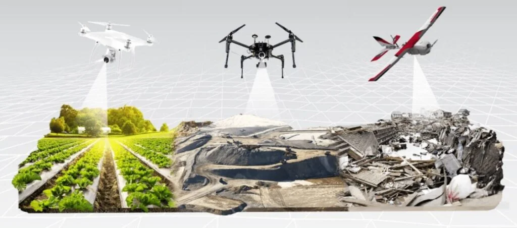
Drone Mapping in Industries
| Constructions | – Creating 3D site models to share with clients – Easily capture accurate pre-bid topos – Reducing downtime and improving scheduling – Calculating volume measurements (cut/fill) |
| Land Surveying | – Producing topographical surveys in approximately 24 hours – Calculating accuracy to 1/10 foot – Using local site caliberation |
| Mining & aggregates | – Stockpile inventory management – Haul road monitoring – Operation planning and assessment – Visualizing progress against linework and design files |
| Waste Management | – Accurate density and volume calculations – Visualizing cell progress – Improving efficiency and maximize cell lifespan |
Through drone mapping, it becomes possible to visualize the progress of a project at each stage, starting from project initiation until the present moment. This enables the tracking of progress over time, providing a clear understanding of the completed tasks and their respective timelines. Consequently, there is no need for speculation regarding the remaining work, ensuring transparency for both you and your stakeholders.
Benefits of Drone Mapping
Accurate
As a result of rapid improvements in UAV and camera technology over the past decade, drones are now able to use cameras that can shoot up to 5.2k resolution images and video. The higher the pixel density, the more accurate the survey is. In addition to improved camera technology, stabilization techniques have also advanced, enabling drones to capture images in the most severe weather condition. This accuracy is one of the drone’s strongest benefits and a key reason why it is a popular survey method.
Time & Cost Effective
The economic advantage of drone mapping comes primarily from its low operating costs compared to its main competitors, airplanes, and helicopters, which are up to 10 times more expensive than drone topography. Besides, recent studies show drone surveying is up to five times faster than traditional land-based methods which are around 10mins per hectare.
Improved Health & Safety
Easy Access
Drones provide convenient access to locations that are challenging to reach, requiring minimal downtime and disruption. By following a pre-determined flight path, drones can effortlessly capture data for structures such as towers, masts, roofs, and wind turbines.
The Cost of Drone Mapping
In order to provide an accurate answer that caters to everyone, it is important to have a clear understanding of your specific requirements for a drone. Some of the high-end drones suitable for mapping would be DJI Matrice 300 RTK Universal Edition which comes with more features and advantages compared to its predecessors. If you need a drone with extended battery life and the capability to survey vast industrial sites like mining and construction areas, we would suggest considering the DJI Phantom 4 RTK. This model offers the essential features for mapping industrial-scale sites while maintaining affordability and reliability, making it an industry-leading option. However, if you are simply seeking a drone for recreational purposes, there are lower-priced alternatives available, typically ranging from a couple of hundred dollars or less.
Software for Drone Mapping
Drone mapping software empowers earthworks and civil construction firms to efficiently map and survey extensive land areas utilizing a drone or UAV. Initially, the drone is deployed to fly over the construction site, capturing a series of overlapping photographs of the terrain. DJI Terra is an easy-to-use mapping software developed to help industry professionals transform real-world scenarios into digital assets. Quickly generate a 2D orthomosaic of the selected area in real time. Not only is this ideal for creating detailed flight paths in remote areas but it’s also useful for time-sensitive missions that require quick decision-making on site. With DJI Terra, you can easily handle and analyze point cloud data captured by the Zenmuse L1. Through a simple click, you can calculate precise position and orientation system (POS) data, integrate point cloud data with visible light data, export point clouds in standardized formats, and generate comprehensive fieldwork reports.
Conclusion
The utilization of drones as tools for creating digital maps is now highly feasible. With the advancements in drone technology, which have resulted in smaller and lighter drones with longer flight capabilities, it is possible to generate digital maps with excellent resolution. These maps can be utilized to aid in data planning. The entire process, from field data collection using drones to the processing and creation of digital maps, can be completed within a matter of hours, unlike traditional optical surveying methods that often require several days.

Comments